The Gorge, the Lake and the Abandoned Channel of the River Murray
Introduction
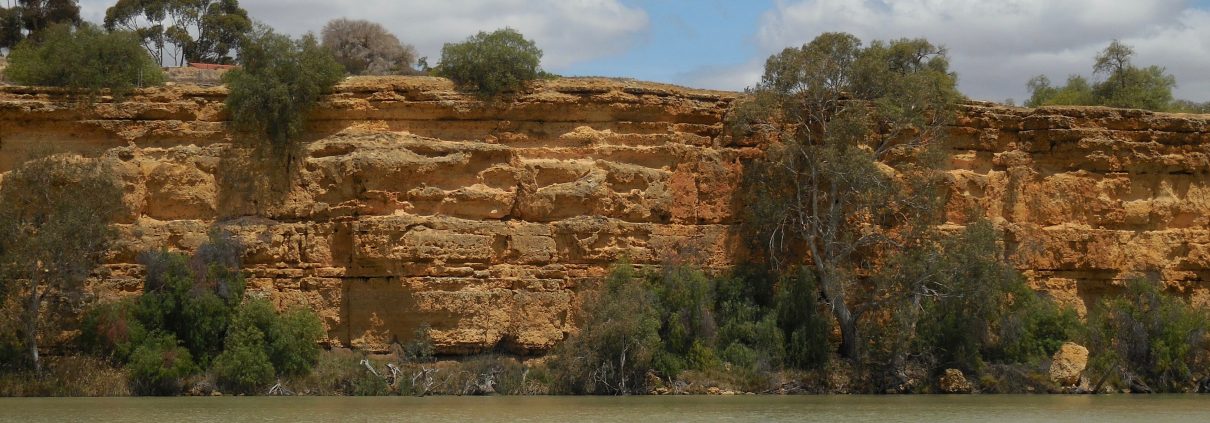
From Overland Corner to Wellington, over three hundred and forty kilometres, the River Murray is carved deep into the landscape exposing thirty metre high pale yellow limestone cliffs.
The gorge is much deeper and wider than today’s relatively small river could create. Its origins lie in a wetter climate, a massive fault block and the palaeo megalake Bungunnia.
The Douglas Depression
In western Victoria an abandoned river connects the Sunset Country to the coast.
Now mostly filled in by sediment, the channel is hard to recognise on the ground. But this river used to drain the Murray-Darling Basin to the sea.
The Douglas Depression is over two hundred kilometres long. Commencing north of Wyperfeld National Park, it runs south to Douglas. It curves west around the resistant sandstone of Mount Arapiles, then continues south-west towards the coast. The depression is up to twenty kilometres wide but shallow – only thirty to fifty metres lower than the surrounding landscape. But it strongly influences present-day drainage systems. The Wimmera River, when it reaches the depression near Natimuk, turns north. The Glenelg River reaches the depression at Harrow and follows it south-west. Along its length are scattered shallow saline wetlands and lakes including Mitre Lake and White Lake in the south and the Wimmera Terminal Lakes in the north: Lake Hindmarsh, Lake Albacutya, Lake Agnes and the Wirrengren Plain.
Oblique Google Earth image of the Douglas Depression looking north from Balmoral.
Below the surface, the depression is carved up to forty metres into the surrounding geology. It cuts through the dune ridges of the Loxton Parilla Sands and deeper into the underlying limestone.
The western shore of Lake Hindmarsh where the Douglas Depression eroded a cliff into the Loxton Parilla Sands. Photo Lance Lloyd.
The depression was created over five million years ago and discharged to the sea near Portland.
Lake Bungunnia
This ancient River Murray was defeated by a tectonic shift.
The Padthway High is a fault block that stretches from the Grampians to the Mount Lofty Ranges, parallel to the coast.
Adapted from McLaren et al. (2011)
The block was raised 2.4 million years ago, raising with it the bed of the Douglas Depression. Flow from the Murray-Darling basin was gradually choked. With no outlet to the sea a vast freshwater lake was created inland.
Lake Bungunnia is the name given to the lake that extended over the lower Murray-Darling Basin between 2.4 million and 700,000 years ago. The lake initially extended from Swan Hill to Swan Reach, north to Menindie and south to Pinnaroo. At its greatest extent the lake covered 90,000 square km. Today’s largest freshwater lake, Lake Superior, is 82,000 square km.
We know the extent of Lake Bungunnia by the erosion of ancient shorelines and the characteristic grey-greenish clay of the lake bed. The clay has since mostly been buried by windblown sands.
But the lake continues to influence ecosystems today: Lake Tyrrell, the Raak Plain and Noora Basin are all formed on the exposed bed of Lake Bungunnia.
The River Murray Gorge
The maximum extent of Lake Bungunnia was determined by the crest of the Padthaway High. The lake reached a maximum extent in the wet climatic period near the start of its life, and peaked at seventy metres above current sea level. At this level the lake just overtopped the fault block at Swan Reach. This was enough to initiate flow to the sea and to start the erosion of a channel for the future River Murray.
Drier climatic conditions followed and the lake level dropped below the sill. But over the next 1.7 million years, during wet periods, the lake periodically overtopped the sill and reactivated and eroded the channel.
Adapted from McLaren et al. (2012)
At this time the sea level was at least one hundred metres lower than today and the coast was far off the shore of today’s Encounter Bay. This provided a steep gradient from the high point at Swan Reach to the river mouth. Lake outflows cut into the limestone of the fault block to create the Murray Gorge.
Oblique Google Earth image of the River Murray gorge looking upstream near Mannum. Vertical exaggeration x 3.
The gorge finally cut down to the level of Lake Bungunnia 700,000 years ago and drained it completely. But the river continued cutting upstream into the bed of the former lake, completing the gorge at Overland Corner.
Conclusion
The ecosystems we see today are the slowly evolving products of geological and geomorphic processes. We have a much better understanding of how ecosystems work and how to manage them when we understand their environmental setting.
See Also
Further Reading and Sources
Bowler, J. M., Kotsonis, A., and Lawrence, C. R. (2006). Environmental evolution of the mallee region, western Murray Basin. Proceedings of the Royal Society of Victoria 118: 161–210.
McLaren, S., Wallace, M.W., Gallagher, S.J., Miranda, J.A., Holdgate, G.R., Gow, L.J., Snowball, I. and Sandgren, P. (2011). Palaeogeographic, climatic and tectonic change in southeastern Australia: the Late Neogene evolution of the Murray Basin. Quaternary Science Reviews 30: 1086-1111.
McLaren, S., Wallace, M.W. and Reynolds, T. (2012). The Late Pleistocene evolution of palaeo megalake Bungunnia, southeastern Australia: A sedimentary record of fluctuating lake dynamics, climate change and the formation of the modern Murray River. Palaeogeography, Palaeoclimatology, Palaeoecology 317-318: 114-127.
Hill, P.J., De Deckker, P., von der Borch, C. and Murray-Wallace, C.V. (2009). Ancestral Murray River on the Lacepede Shelf, southern Australia: Late Quaternary migrations of a major river outlet and strand line development. Australian Journal of Earth Sciences 56: 135-157.


